
|
Why are these flight plans different |
Post Reply 
|
| Author | |
brou0040 
Senior Member 
Joined: 13 Dec 2012 Location: KIYK Status: Offline Points: 720 |
 Post Options Post Options
") Thanks(0) Thanks(0)
 Quote Reply Quote Reply
 Topic: Why are these flight plans different Topic: Why are these flight plans differentPosted: 09 Dec 2015 at 11:00pm |
|
Ran into this on an actual flight so I'm recreating on the sim to ask the question.
Set the origin as KBLH, firstwaypoint as VICKO, and destination as KTUS. When you select the DINGO5 GBN transition STAR first and the ILS 11L with the DINGO transition second, you get: KBLH,VICKO,--GAP--,GBN,BASER,DINGO,MAVVA,--GAP--,DINGO,TACUB,... Which is not correct according to the STAR If you reverse the order of adding the STAR and the IAP meaning add the ILS first and the STAR second, then you get: KBLH,VICKO,--GAP--,GBN,BASER,DINGO,MAVVA,Hdg 075 Manual,--GAP--,DINGO,TACUB,... Which seems to line up with the STAR. Also, why doesn't it fly the heading then fly inbound to LIPTE, the next waypoint you'd intercept on the localizer if you followed the STAR. Since LIPTE is an IAF, even when you activate the approach, it stays in GPS mode rather than transitioning using the localizer. Since you are outside the IAF, the 540 doesn't transition to VLOC to be able to intercept the localizer anyways, it's still using GPS for navigation. It seems like the 540 thinks it needs manual intervention similar to an altitude terminated leg with no baro input, but the 540 has everything it needs so it should be able to fly the STAR/IAP transition properly with no manual intervention.
Edited by brou0040 - 09 Dec 2015 at 11:01pm |
|
 |
|
|
DavidBunin
Senior Member

Joined: 20 May 2015 Location: Rockwall, TX Status: Offline Points: 742 |
Post Options
Thanks(0)
Quote Reply
Posted: 10 Dec 2015 at 10:18am |
|
That's interesting. One of the more experienced instrument pilots will have to comment, but I notice that the "fly heading 075" instruction on the STAR is only relevant if you are expecting the ILS11L approach. If you are expecting runway 29R then that instruction is not part of the STAR. I guess for landing 29R you should expect the first vector prior to reaching MAVVA. Also, once you've passed MAVVA and you're flying 075, you'll never get back to DINGO. I'm not even sure if you'd hit the localizer course outside of TACUB. |
|
|
|
|
brou0040
Senior Member
Joined: 13 Dec 2012 Location: KIYK Status: Offline Points: 720 |
Post Options
Thanks(0)
Quote Reply
Posted: 10 Dec 2015 at 9:27pm |
|
I've noticed that the 540 changes your waypoints or sequence of waypoints based on procedures you select (it may put the IAF of a second approach into the missed of your first approach - still not satisfied with understanding the reason for that).
It's almost as if when adding the STAR after the ILS, it knows to add the heading since it knows you expect the ILS. I can see not having the manual heading leg when you only load the STAR without the ILS, but once you also add the ILS, it should modify the STAR so you end up with the same set of waypoints regardless of the order the procedures were entered. What I don't like about this is that you don't want to close the gap from the STAR to the ILS because you don't want to fly back to DINGO. Actually, you CANNOT close the gap between the STAR and the ILS because the GAP is inside the ILS procedure where you CANNOT remove waypoints - the ability to do this has already been requested. I was expecting a LSK to sequence the leg manually (although I think the 540 should be smart enough to do this automatically since it has all the information it needs unlike a non-baro altitude terminated leg), but instead all I had was to activate the approach, which creates a large semi-circle back to DINGO, which is totally incorrect. The correct way to do this (I think) is to not activate the approach, but to simply hit direct to the next waypoint along the localizer. The problem is that you don't know what that point is based on the STAR or the procedure, you only know that by looking at the moving map page zoomed in to see where the different waypoints are with respect to where the heading intersects the localizer - I supposed you could be twiddling multiple VORs... Now the trick is to NOT BE ON THE AUTOPILOT when you do this because if you are slightly beyond where the 540 thinks you can make a smooth turn onto the ILS, it makes you fly a gigantic circle away from the airport!!! The picture is a bit exaggerated flying past the localizer since I didn't get the screenshot right away, but I think it shows the issue. The size of the circle may also be exaggerated by the airspeed I was using in the sim, but I'm not sure. 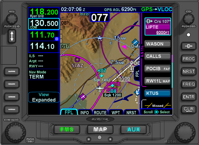 I assume you can pick up the localizer that far out because that is what the STAR expects.
Edited by brou0040 - 10 Dec 2015 at 9:31pm |
|
|
|
|
Post Reply
|
|
 Tweet
Tweet
|
| Forum Jump | Forum Permissions You cannot post new topics in this forum You cannot reply to topics in this forum You cannot delete your posts in this forum You cannot edit your posts in this forum You cannot create polls in this forum You cannot vote in polls in this forum |


 Topic Options